

FREEZING RAIN AND ICE | Jan 21st update | Mr G
Well if this was a school day, I would guarantee you kiddies and teachers, through much of the state you would not be going to school (I'm sure they're saying "What a waste of a storm.") The roads especially secondary roads are very icy as a result of the snow/sleet and freezing rain that fell over night. Right now here in Northern St Mary's County in Mechanicsville I am reporting Freezing Rain and 31 degrees. Everything is pretty much icing over on top of that 1/2 inch to 1 inch of snowfall that accumulated here last night. We are also reporting freezing rain over the mid eastern shore, the DC/Balt metro area, Annapolis, and Garrett County. Its still snowing across a thin sliver along the Mason-Dixon Line from Carroll over to Cecil Counties. The precipitation should end by early afternoon as all rain except in the far north Balt suburbs where we will not see a changeover to plain rain. We are keeping an eye on tomorrow where there is a possibly of more freezing rain/ice through much of the Western Shore of Maryland. For now, if you go out this morning, take it easy driving in this mess. (MR G)
Map and Advisory Update | Josh O
 |
| Regional Radar Still from Intellicast |
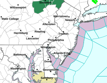 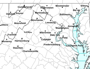 |
LEFT: NWS Sterling Map | RIGHT: NWS Mt Holly Map PURPLE: Winter Weather Advisory (Read Below) PINK: Special Weather StatementTAN: Hazardous Weather Outlook GREEN: Coastal Flood Statement |
ALL ADVISORIES DROPPED.