

Temps are slow to rise and the lower level of cold air has been staying stubbornly in place today-its still below freezing in many locations across the state even into the deepest reaches of southern Maryland. I would not be at all surprised if we do not see a rise in temps this afternoon to the forecast high of mid 30s, that NWS issues extends the advisory to St Mary's as well-we'll see. As the freezing rain falls, temps in the advisory area are looking to hover right around freezing until the early morning hours after which temps should gradually rise into the upper 40s and low 50s by Monday afternoon as warmer air from the south begins to win out over the stubborn lower layer of cold air and all precip changes from south to north to plain old rain for everyone even into the far reaches of Western Maryland mountains. For now be cautious driving this evening and early tomorrow morning.
Maps and Advisories | Josh O
 |
| Regional Radar Still from Intellicast |
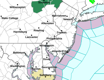 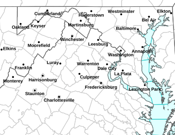 |
LEFT: NWS Sterling Map | RIGHT: NWS Mt Holly Map
|
 |
| Latest Ice Forecast from NWS Sterling |
The National Weather Service in Sterling has issued a Freezing Rain Advisory for ALL of MARYLAND EXCEPT FOR THE DELMARVA, ST. MARYS, and GARRETT COUNTIES. NORTHERN VIRGINIA is in it as well.
126 PM EST SUN JAN 22 2012

...FREEZING RAIN ADVISORY IN EFFECT UNTIL 6 AM EST MONDAY...

THE NATIONAL WEATHER SERVICE IN BALTIMORE MD/WASHINGTON HAS
ISSUED A FREEZING RAIN ADVISORY...WHICH IS IN EFFECT UNTIL 6 AM
EST MONDAY.

* PRECIPITATION TYPE...FREEZING RAIN AND FREEZING DRIZZLE.

* ACCUMULATIONS....A TRACE TO LESS THAN A TENTH OF AN INCH.

* TIMING...LATE THIS AFTERNOON THROUGH EARLY MONDAY MORNING.

* TEMPERATURES...UPPER 20S TO LOWER 30S.

* WINDS...NORTHEAST UP TO 5 MPH.

* IMPACTS...LIGHT ICING ON ROADWAYS AND ELEVATED SURFACES WILL
  MAKE TRAVELING HAZARDOUS.

PRECAUTIONARY/PREPAREDNESS ACTIONS...

A FREEZING RAIN ADVISORY MEANS THAT PERIODS OF FREEZING RAIN OR
FREEZING DRIZZLE WILL CAUSE TRAVEL DIFFICULTIES. BE PREPARED FOR
SLIPPERY ROADS. SLOW DOWN AND USE CAUTION WHILE DRIVING.