

UPDATE ON SNOW AND PRECIP | Mark G | Winter Analysis, UPDATED Saturday, 10:29a
1st Stage of Snow about through, waiting for arctic front and 2nd batch of snow. Transitioning to all snow with the exception of the lower eastern shore where it is 41 degrees and light rain in the Salisbury Ocean City area. I am reporting light snow and 34 degrees here in Mechanicsville, ST Marys County. This first stage of the snow has left 1-2 inches just to the north and west of Baltim ore and Washington-everywhere else just saw a trace or wet snow that did not lay. Now as you can see on the attached radar map, there is a break in the precip, we should see until about afternoon time. As the arctic front arrives, we'll begin to see that second wave of precip begin to move east and drop snow showers, maybe some heavy snow squalls later this afternoon into the evening. This 2nd batch should be mostly in the form of snow across most of the state. Hard to tell yet how much snow that will drop, but we'll keep you updated. At any rate, watch for icy roads later this afternoon through the early morning hours Sunday.
MAPS AND ADVISORIES UPDATE | LAST UPDATE: 2:24p
 |
| Regional Radar Still from Intellicast |
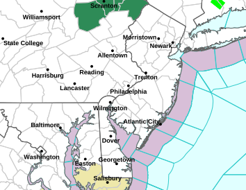 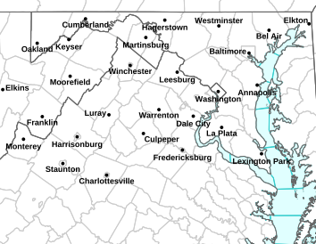 |
LEFT: NWS Sterling Map | RIGHT: NWS Mt Holly Map
Purple: Winter Weather Advisory Pink: Winter Storm Warning Light Tan: Hazardous Weather Outlook Brown: Wind Advisory |
The National Weather Service in Sterling has issued a Wind Advisory for ALL MARYLAND counties west of the Chesapeake until 7am Sunday. Winter Storm Warning for Garret until 7p Sunday.
The Wind Advisory Reads (NWS):
1238 PM EST SAT FEB 11 2012

...WIND ADVISORY IN EFFECT FROM 7 PM THIS EVENING TO 7 AM EST
SUNDAY...

THE NATIONAL WEATHER SERVICE IN BALTIMORE MD/WASHINGTON HAS
ISSUED A WIND ADVISORY...WHICH IS IN EFFECT FROM 7 PM THIS
EVENING TO 7 AM EST SUNDAY.

* TIMING...TONIGHT. THE HIGHEST GUSTS ARE LIKELY THIS EVENING.
* WINDS...NORTHWEST 25 TO 35 MPH WITH GUSTS UP TO 50 MPH..